
Ecuador: Satellite image shows suspected pipeline in Ishpingo-Tambococha-Tiputini block
news.mongabay.com/ Jeremy Hance reported Mongabay has obtained a new, high-resolution satellite image of Petroamazona’s suspected pipeline and drilling platforms in the famed Ishpingo-Tambococha-Tiputini (ITT) block. Obtained from Planet, the image was analyzed by the team at the Monitoring of the Andean Amazon Project (MAAP) just after Ecuador announced it had begun drilling in arguably the most biodiverse place on the planet.
With a resolution of three meters, the image shows a snaking pipeline amid the unbreakable green of the rainforest that ends in rectangles, which are believed to be oil platforms. The picture is especially important given a blackout on outside monitoring of the ITT drilling. Read Article
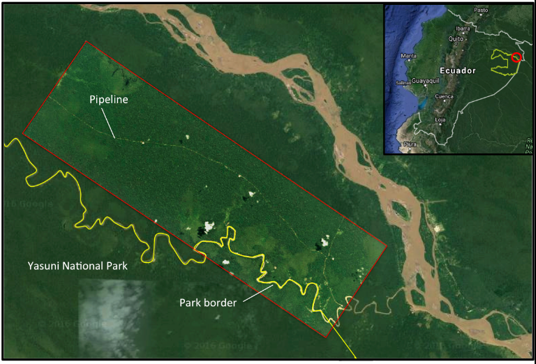
A high resolution (3 meters) of the drilling platform and pipeline in the ITT block of Yasuni from September 2016, overlaid on Google Earth imagery from 2007. This platform lies just outside the Yasuni National Park, but future platforms will move inside the park. Image by: Planet with analysis by MAAP and Google Earth Imagery.


Africa
- Number of Africans, surge in Latin America trying to get to the U.S.
- Sunni Extremists entering U.S with help from alien smugglers in South America
- Mexico giving unvetted Africans pass to get to U.S. Border
- Surge of African immigrants arrive Mexico, seeking transit to U.S. for asylum
- Five Ghanaians found dead on Colombia-Panama border in route to U.S.
Archaeology
- Mexico: Life Forms as old as 50,000 years found in cave network
- Cuenca Ecuador: Nearly 500 year old street reopens after being closed for 50 years
- Nazca Lines Peru: new geoglyphs found after sand storms
- Pucara de Rumicucho, Incan Stone Fortress north of Quito Ecuador
- Cuenca Ecuador: City is preserving landmarks of its ancesetral beginnings
Argentina
- Argentina: Tourist from UK found dead in Tierra del Fuego
- Argentina: Expat allegedy murdered in his home by male prostitute
- Buenos Aires Argentina: After 140 years English language newspaper shutting down
- Argentina: 10,000 victims of human trafficking rescued in past decade
- Argentina Crime Rate Registers 6% lower in 2016 compared to 2015
Asia
- Thailand: Woman from Ecuador behaving strangely, leads to 2.35 kg of cocaine disguised as beauty cream
- North Korea accuses Mexico of illegally detaining ship
- More African, Asian migrants using Costa Rica on route to U.S., Canada
- Nepal citizens arriving in Ecuador by sea, using as route to the U.S.
- 40 Percent of New Vehicle Sales in Ecuador from Asia
Ayahuasca
- Ecuador: Shaman to be sentenced to Prison Term in Death of U.S. citizen, during Ayahuasca Ceremony
- Ecuador: Shaman Found Guilty In Death of U.S. Citizen During Ayahuasca Ceremony
- Ecuador: Trial for Shaman in death of U.S. citizen recesses for two weeks after two days of proceedings
- Ecuador: Investigation in death of U.S. citizen Leslie Allison continues according to Shaman
- Shaman declines to comment on death of American Leslie Allison in Ecuador
Belize
- Belize: FBI believes more than one person involved in murder of U.S. tourist year ago
- Belize: Six French citizens in tour van accident, injuries
- Tourist from U.S. Strangled, Murdered in Belize
- Expat's Audacious Move to Belize
- Bank of America suspending international wire transfers to and from banks in Belize
Bolivia
- Brazil: Operation Ostium combating suspected air traffic on borders
- Peru: Striking teachers block border crossings to Bolivia and in areas of Cusco
- La Paz Bolivia: Bizarre Case of Dead Woman Found Alive In Funeral Home
- Boliva: Two police detained in smuggling of foreing women for prostitution case
- Chinese Smugglers in Bolivia involved in trafficking of jaguar teeth
Border Issues
- Peru Strengthens Migratory Control at Tumbes near Ecuador Border
- Brazil: Troops sent to border town after Venezuelans attacked
- Ecuador Declares State of Emergency in Three Provinces due to Migrant Surge
- Ecuador Asks Colombia To Protect Border From Guerrilla Dissenters
- Man from California attempts to smuggle tiger cub into U.S. from Mexico, pleads guilty
Brazil
- Brazil: Troops sent to border town after Venezuelans attacked
- Rio de Janeiro Brazil: Tourist shot, killed by police while on tour of favela
- Brazil: British tourist (canoeist), shot, sexually assaulted, murdered on river trip
- Brazil: Lead Suspect in Robbery & Murder of British Tourist Kayaker, killed
- Brazil: Lead suspect in robbery and murder of British tourist kayaker, killed
Brazil Travel
- Yellow Fever Alert for Brazil, spreads to major population areas
- Zika Virus not only concern for visitors to olympics, be aware of chikungunya virus
- Brazil: Dark Side of the Olympics, Sex Workers offer specials to lure foreign clientele
- Rio de Janeiro Brazil: Police threaten to strike during Olympics
- Brazil Olympics: Group urges olympic games to be postponed or moved from Rio de Janeiro (Zika Virus)
Cacao Global
- Commodities firm stops buying cocoa from Ecuador
- Improving the organisation and commercialisation of small coffee and cocoa producers in the Northern Amazon Region of Ecuador
- Chile: Imports of chocolates grew 35 % in 2011
- Ecuador claims to have 62% of the world's market for high quality cacao
- Ecuador among top ten cocoa producing countries
Caribbean
- Granada: U.S. Tourist Murdered with Machete
- Antigua Caribbean: Coconut Palms Dying Off
- Philipsburg, Sint Maarten: Tourist dies while on diving trip
- Caribbean countries fishing sectors warned of ocean acidification
- 100 percent of the Latin American and Caribbean population is susceptible to Chikungunya fever
Central America
- Large Numbers of Migrants flee Central America for the U.S. since Trump elected
- Hurricane Otto threatens Central America
- El Salvador: Women serving prison terms for abortions they said they never had
- U.S to spend $1.5 million in Mexico, Central America for wildlife preservation
- Number of Africans, surge in Latin America trying to get to the U.S.
Chile
- Arica, Chile 6.3 Earthquake (Video)
- Ecuador, Chile: Analysis of Corruption in Police Forces
- Santiago Chile: Man dead from tuberculosis found sitting in chair on public street
- Santiago Chile: Tourist dies outside airport of heart attack, delayed medical care due to uber, cabify protest
- Chile: Semi Trucks Set on Fire in arson attack, evidence points to Indigenous group
Ciudad Juárez
- Loja Ecuador: 124 tonnes of onions seized, infested with pests, flies, larvae, fungus
- Mexico: 13 'Hot Spots' for Human Trafficking Identified
- Mexico: Police Detain12 Suspected of Murdering 11 Young Women
- Ciudad Juarez Mexico: returns to life four years after being labeled most dangerous city
- Ciudad Juárez Mexico, no confirmed cases of West Nile Virus
Colombia
- Ecuador Declares State of Emergency in Three Provinces due to Migrant Surge
- Wave of Bomb Attacks in Colombia, authorities expect more to come
- Medellin, Colombia: Two tourists drugged with scopolamine, one dead
- Bogota, Colombia: Australian woman detained for smuggling cocaine at airport
- Colombia: Rights Violations, Atrocities need to be addressed in post conflict phase
Conflicts
- Comrade Insider Shares Opinion as to what is going on in Ecuador
- Venezuela Crisis Deepens
- Academic Calls for Invasion of Venezuela
- Ecuador: Prosecutor to request former President Correa to be barred from leaving country
- HE'S BACK. Former President Rafael Correa arrives in Ecuador, political feud continues with current Pres.
Corruption
- Ecuador: Opposition Seeks Investigation into Alleged Acquisition of Luxury Apartment in Spain by Front men For President
- Ecuador: Former Minister Admits to Taking Bribe from Odebrecht
- Ecuador: Video of Police Assaulting Suspect on the Ground
- Corruption Within Ecuador's 911 Emergency System? A Missing Report
- Mexico: A unique tour demonstrating the pervasiveness of corruption
Crime
- Quito, Ecuador: Texas Oilman Detained and investigated for trafficking and sexual exploitation
- Quito, Ecuador: Elderly U.S. citizen detained for investigation in teenager's death
- Montanita, Ecuador: Two U.S. Citizens Detained in suspected Kidnapping of Child
- Peru: Band of Rolex Thieves raising havoc
- Ecuador: U.S. Expat Brutally stabbed to death in his residence by assailant, wife injured
Cuba
- Cuba: Sound Sample of Sonic Warfare that diplomats heard
- Cuba honors Ecuador President Correa for Assistance in Construction projects
- Cuba: Google Activates Line of Caching Servers
- One Expat's story in Cuba, how life can go wrong very fast
- Ecuador: Group of Cuban Doctors ask for end of xenophobia and end to medical missions
Dominican Republic
- Dominican Republic: Mysterious village where some girls grow into boys at puberty
- Dominican Republic: Two Journalists Shot Dead During Live Facebook Broadcast
- Dominican Republic: Three U.S. citizens, Canadian model arrested, allegedly filming scenes for porno movie in public
- German Tourist Murdered over necklace by assailants in Dominican Republic
- U.S. Citizen Murdered in Dominican Republic
Drug Activity
- Ecuador: Drug Trafficking Statistics
- Medellin, Colombia: Two tourists drugged with scopolamine, one dead
- Four Mexican Drug Cartels Have Presence in Ecuador
- Ecuador: Anti-Narcotic Unit Ambushed near Colombia border in San Lorenzo
- Drug Arrest Colombia: Aussie Claims the proof of innocence in locked phone
Ecuador
- RELOCATION SERVICES TO ECUADOR - TOURS TO ECUADOR - JOURNEYMAN JACK
- Quito, Ecuador: Texas Oilman Detained and investigated for trafficking and sexual exploitation
- Quito, Ecuador: Elderly U.S. citizen detained for investigation in teenager's death
- Montanita, Ecuador: Two U.S. Citizens Detained in suspected Kidnapping of Child
- Ecuador: Massive Layoffs in Public Service Sector Reported
Ecuador Emergency
- Quito, Ecuador: Texas Oilman Detained and investigated for trafficking and sexual exploitation
- Quito, Ecuador: Elderly U.S. citizen detained for investigation in teenager's death
- Ecuador: U.S. Expat Brutally stabbed to death in his residence by assailant, wife injured
- U.S. citizen from Washington State Murdered in Ecuador
- Missing Expat in Ecuador from U.S. discovered deceased in Florida
Ecuador Hotels
- Ecuador: Flowing River Resort, located high in the Andes mountains, quiet serenity
- Rincón d'Olón Suites and Studios in Olón, Montañita Ecuador
- Coco Bongo Hostal Bahia de Caraquiz Ecuador
- Black Sheep Inn Eco-Lodge, Cotopaxi Ecuador
- Bromelia Nature Lodge Retreat / Healing Center Montanita, Manglaralto Ecuador
Ecuador Real Estate
- RELOCATION SERVICES TO ECUADOR - TOURS TO ECUADOR - JOURNEYMAN JACK
- Ecuador: Professional Relocation Services, Journeyman Jack
- EcuaAssist, Full Expert Services for the Expat in Ecuador
- Real Estate Sales/Rentals Salinas, Ecuador - Island Estates International
- Ecuador: Real Estate Tours in Southern Ecuador
Ecuador Services
- RELOCATION SERVICES TO ECUADOR - TOURS TO ECUADOR - JOURNEYMAN JACK
- Ecuador: Professional Relocation Services, Journeyman Jack
- Expats Recommend Book for Those Moving to or Living in Ecuador
- EcuaAssist, Full Expert Services for the Expat in Ecuador
- Real Estate Sales/Rentals Salinas, Ecuador - Island Estates International
Ecuador Travel
- RELOCATION SERVICES TO ECUADOR - TOURS TO ECUADOR - JOURNEYMAN JACK
- Ecuador: Professional Relocation Services, Journeyman Jack
- Guayas Province Ecuador: Tourist Dies in Jump from Waterfall( VIDEO)
- Ecuador: Public Transport Safety, How to avoid a kidnap express
- Ecuador: Bus Driver Fired After Video Goes Viral After Checking Cell Phone While Driving (Video)
Ecuador Trivia
- Quito Ecuador (1998) Cuban airliner crashes just after takeoff
- Pan Am-Grace Flying Boat crashes in route from Guayaquil Ecuador to Panama (1937)
- Ecuador: Results of 15 Year Study regarding suicide in Ecuador
- Ecuador: Expat from U.S. in early 20th Century contributed to building of country
- Ecuador: Eucalyptus production zapping water supply from indigenous farmers
El Salvador
- El Salvador: Television personality accused of drug trafficking with Ecuador connection
- El Salvador: Women serving prison terms for abortions they said they never had
- El Salvador: State of Emergency Declared at Seven Prisons
- Former President of El Salvador dies while under house arrest
- Zika Virus: Health Officials Colombia, Ecuador, El Salvador advise women to postpone pregnancy
Enviromental Issues
- Ecuador Defends Oil Drilling in Yasuni National Park
- Ecuador: Report, conflict between Shuar tribe and govt. causing psychological damage
- Machala, Ecuador: Famous Iguanas of Parque Plaza Colón slaughtered with rat poison (video)
- Company in Ecuador breeds rare frogs, trying to stop illegal pet trade
- World's Largest Mining firm opens office in Ecuador - TARGET IS COPPER
Explosives / Bombs
- Wave of Bomb Attacks in Colombia, authorities expect more to come
- San Lorenzo, Ecuador: Possible Car Bomb Leaves 14 Police Wounded in Barracks (VIDEO)
- Ecuador receives certification for detecting nuclear tests, stations located on Galapagos Islands
- Bogota Colombia: Three Dead, in shopping center bomb explosion, tourist district
- Ecuador, Colombia border: Explosives, Ammunition found by task force in April
Extortion
- Mexico: Immigration Officials Accused participating in criminal network, blackmailing relatives
- Mato Grosso do Sul, Brazil: Police Officers Detained for Extortion and Corruption Charges
- El Salvador: businessmen complain authorities do little to curb extortion
- Ecuador: Despite warning from President Correa, police continue corruption of demanding money from victims to investigate
- Head of La Familia Michoacana drug trafficking organization caught in Mexico
Falkland Islands (Malvinas)
- Argentines' upset over call to rename Falkland Islands capital, Port Margaret
- Crisitna Fernández rejects Falkland Island's referendum, calls voters as squatterss
- Falkland Islands: referendum results, no desire to be governed by Argentina
- Falkland (Malvinas) islanders to vote on sovereignty
- Argentina accuses Britain of sending nuclear ships to Falklands
FARC
- Ecuador: Kidnapped Reporters Dead
- Ecuador Bombing: Mastermind of Terrorist Attack Identified as FARC dissident
- Colombia: United Nations issues alert in five areas despite peace truce with ELN
- FARC dissidents may be behind drug lab along Colombia,Ecuador border
- Colombia: Violence spreading in areas abandoned by guerrillas
Guatemala
- Guatemala: Remote Controlled Explosive Devices Used on Bus Attacks
- Guatemala: 49 cases of Zika virus registered in past three weeks
- Guatemala: Every dreamed of sleeping in Che Guevara's bed? Here is your chance, nine dollars
- Guatemala: 17 dead in violent prison brawl
- Guatemala: Graves whose lease has expired or not paid, bodies being exhumedved
Guyana
- Guayana: Five charged in murder of tourist from UK
- U.S. Embassy advises U.S. citizens not to use Caribbean Airlines on Flights from Guayana to U.S.
- Guyana: October 2013, U.S. oil search ship detained by Venezuela navy
- Guayana: visit teenager from Ireland charged after threatening to assasinate president
- Guayana: Breeze Soap Powder shipment contained 350 kilos cocaine set to ship to Africa
Health
- Haiti Prison, HELL ON EARTH, some waiting up to eight years for trial
- Rabies from dog bites persisent problem Latin America and worldwide
- Ecuador: Dengue Cases Up in Three Provinces but down across the country
- São Paulo, Brazil: Study Reveals Genetic Diversity of HIV in Infected Patients
- Doctors in Brazil Plan Electoral Campaign Against Incumbent President Dilma
Honduras
- Disbarred Attorney from U.S. Convicted of plotting to fly cocaine from Ecuador
- Honduras: Human Rights Groups Report number of murders of women up sharply
- Honduras: Three Convicted in Plot to murder President
- Honduras: High Risk Inmates being transferred to new maximum security prison
- Roatan Honduras: German Tourist dies while snorkeling
Human Rights Latin America
- LGBT Rights in Ecuador
- U.S. Role in support of Criminal Justice Reform In Mexico
- Ecuador: Anti-Press Campaign by Former President Correa, caused lasting damage to journalism
- Ecuador: Foreign Ministry still aligned with former President's position on free speech
- Argentina: 10,000 victims of human trafficking rescued in past decade
Human Smuggling
- Quito, Ecuador: Elderly U.S. citizen detained for investigation in teenager's death
- Argentina: 10,000 victims of human trafficking rescued in past decade
- Ecuador: Sex Trafficking of the Indigenous, seldom reported or discussed
- Three Ecuadorian women accept work in Chile to find out it was sex work, escape
- Sonoita Arizona: Human Smugglers Stopped bringing in Mexican Nationals
Intelligence
- Ecuador's Intelligence Capabilities (2013)
- Colombia: United Nations issues alert in five areas despite peace truce with ELN
- Latin America key center for Hezbollah's global financial network (observations, opinion)
- Nicaragua: Russia constructing electronic intelligence facility
- Detained ISIS operative confirms terrorist operating cells in Anapra Mexico
Internet
- Ecuador Mobile Phone Operators to tackle stolen phone problem, improve natural disaster response
- Ecuador: Outlook for 4G Broadband Networks
- Supermaxi Ecuador victim of social media spreading of fake offers from retailer
- Study Says Out of 78 Countries, Ecuador Scores Next to Last in 4G Speed/Service
- Ecuador: State Owned CET to invest $4.3 million in high-speed broadband communications for govt.
Labor Issues
- Peru: Striking teachers block border crossings to Bolivia and in areas of Cusco
- 100,000 rally in Guayaquil Ecuador in launch of proposed labor laws
- Ecuador: Labor Unions, Indigenous Groups call for new protests on Nov. 19, 2014
- Ecuador: History of Preventative Resistance and Violent Suppression, Intag Valley
- Santiago Chile: Thousands of Passengers impacted by transportation strike
Latin America Aviation
- Quito Ecuador (1998) Cuban airliner crashes just after takeoff
- Pan Am-Grace Flying Boat crashes in route from Guayaquil Ecuador to Panama (1937)
- Costa Rica: Ten U.S. Citizens Perish in Plane Crash
- Guayaquil International Airport to Suspend Some Flight Operations Nov. 25, and Dec. 2, 2017
- TAME Flight suspended, Quito - New York due to unscheduled maintenance
Latin America Book Review - Recorded Interviews with Authors
- A History of Modern Latin America 1800 to the Present
- Ritual and Remembrance in the Ecuadorian Andes
- The Guinea Pig - Healing, Food, And Ritual In The Andes
- Begging As A Path To Progress - Indigenous Women And Children And The Struggle For Ecuador's Urban Spaces
- Magical Writing in Salasaca - Literacy and Power in Highland Ecuador
Latin America Health
- Ecuador: Massive Layoffs in Public Service Sector Reported
- Expat states concerns about medical care in Ecuador
- Guayaquil, Ecuador: Conjunctivitis Outbreak Sending Hundreds for Treatment
- Venezuela: Entire Health Care System on Verge of Collapse
- Ecuador postpones six months new health insurance requirement for foreign visitors and tourists
Latin America Indigenous Issues
- Ecuador: President is Urged to Protect Human Rights Defenders and Activists after attacks
- Ecuador: Report, conflict between Shuar tribe and govt. causing psychological damage
- Ecuador: President Moreno making efforts to dialogue with Indigenous groups
- Chile: Semi Trucks Set on Fire in arson attack, evidence points to Indigenous group
- Ecuador: Sex Trafficking of the Indigenous, seldom reported or discussed
Latin America Mining
- Ecuador: Report, conflict between Shuar tribe and govt. causing psychological damage
- World's Largest Mining firm opens office in Ecuador - TARGET IS COPPER
- Geologist Searching for Two Lost Cities of Gold in Ecuador
- Ecuador expects mining investments to increase 360%
- Ecuador: Progress Stalls Out over mining Dispute between govt and Shuar Indigenous Group
Latin America News
- Quito, Ecuador: Texas Oilman Detained and investigated for trafficking and sexual exploitation
- Missing Expat in Ecuador from U.S. discovered deceased in Florida
- Nicaragua: Political Unrest Causes Tourism Industry to Collapse
- Briceño, Manabi, Ecuador: Home Invasion of Expats residence (Video)
- Ecuador: Former President Correa Pelted with an egg (Video)
Latin America Wikileaks
- Latin America: Assange claims NSA eavesdrops on 98% of communications from South America
- U.S. ambassador explains corruption in cable released by WIKILEAKS concerning Brazil
- Ecuador, Wikileaks cable discusses long term impact of melting glaciers
- Jamaican Prime Minister states U.S. officials misrepresented him in diplomatic cables
- Wikileaks shows U.S. and Brazil to partner against drug trafficking
Latin America Womens Issues
- Ecuador: Number of femicide cases up, women demand state of emergency
- Ecuador: Statistics regarding femicide include 77% attackers use knives, strangulation
- Honduras: Human Rights Groups Report number of murders of women up sharply
- Quito Ecuador: City wants to relocate sex workers from historic center
- Nicaragua: National Assembly to reform law to combat gender-based violence
Mexico Travel
- Suggestions on Contacting Friends and Family in Mexico after earthquake
- No Reason to Panic travelling to Mexico says intelligence firm
- Michoacán, Mexico: Tourist from Ireland murdered, girlfriend from Arizona injured in robbery
- Lu’um Balam, Cancun Mexico: Russian tourist dead in bio park cavern, body not recovered
- Cabo San Lucas, Mexico: Cartel Gunmen Storm Popular Tourist Beach Beach (Video)
Nicaragua
- Nicaragua: Political Unrest Causes Tourism Industry to Collapse
- Some Americans May Dump Trump, thinking of moving to latin america
- Nicaragua: Russia constructing electronic intelligence facility
- 13 die as tourist boat capsizes near Corn Islands Nicaragua
- Nicaragua: Inter-Oceanic Canal Project put on hold
Oil
- Ecuador enters new agreement to pay debt to Schlumberger
- Ecuador's attempt to extort Chevron begins to wind down (Opinion)
- Ecuador Defends Oil Drilling in Yasuni National Park
- Ecuador has plenty of unharnessed oil potential, most of it under the Amazon forest
- Ecuador: Military locates clandestine oil operation connected to national pipeline
Panama
- Pan Am-Grace Flying Boat crashes in route from Guayaquil Ecuador to Panama (1937)
- Panama: U.S. Tourist Found Strangled to Death
- Panama: Protests over Political Scandal
- Top Five Retirement Destinations for 2017: Mexico, Panama, Ecuador, Costa Rica, Colombia
- Some Americans May Dump Trump, thinking of moving to latin america
Paraguay
- Brazil: Operation Ostium combating suspected air traffic on borders
- Paraguay, Major Marijuana Powerhouse
- Paraguay: Major Heist of Security Firm, nets millions of dollars
- Paraguay: 25 Tons of Venezuelan Bills(currency) found in home
- Argentina, Paraguay, Brazil, Uruguay: Flooding causes evacuation of over 100,000 people
Peru
- Peru: Band of Rolex Thieves raising havoc
- Peru Strengthens Migratory Control at Tumbes near Ecuador Border
- Lima Peru: Authorities locate dead dogs destined to be sold to Chinese Restaurant
- Peru: Off of Coast 7.1 earthquake, deaths, damage reported
- Cusco, Peru airport: Tourist detained for trafficking in protected species insects
Police/Military Activity
- Brazil: Troops sent to border town after Venezuelans attacked
- Ecuador Asks Colombia To Protect Border From Guerrilla Dissenters
- Ecuador: Video of Police Assaulting Suspect on the Ground
- Colombia: United Nations issues alert in five areas despite peace truce with ELN
- Ecuador Corruption Network Exposed for Candidates to Gain Entrance to Police Academy
Politics
- Think Freedom of Political Comment is Free in Ecuador? Maybe, but not if you are a refugee
- Ecuador Asks Colombia To Protect Border From Guerrilla Dissenters
- Comrade Insider Shares Opinion as to what is going on in Ecuador
- Ecuador: Former President Correa Pelted with an egg (Video)
- Ecuador: Protester Verbally Dresses Down Correa Body Guards taking pictures of her license plate (Video)
Puerto Rico
- Puerto Rico: Intercontinental Hotel Robbed
- Puerto Rico: Pension Plan Changes causes feeling of insecurity
- Tourist from Minnesota dies while snorkeling in Puerto Rico
- Countries in Caribbean examine decriminalization and legalization of marijuana
- Arrest made in Bomb Threat for Jetblue Plane in Puerto Rico
Religion
- El Salvador: Women serving prison terms for abortions they said they never had
- Iquitos Peru: One of the last Jewish Communities in Amazon Basin may disappear
- Expert's view on Iran's export revolution to Latin America
- Fanesca in Ecuador, a soup like no other
- Mexico: Pope's jet attacked by laser on final approach to Mexico City
Shining Path
- Ayacucho Peru: Shining Path painted symbols showing up in historic city center
- Peru: 24 detained, suspected of ties with Shining Path
- Peru: Sendero Rojo maintains 100 bases throughout VRAEM
- Peruvian Military Destroys Clandestine Airstrip in the Jungle
- Cusco Peru: Shining Path may increase kidnappings after rainy season, Hunt Oil possible target
Sinaloa
- Ciudad Juarez, Mexico: Authorities Capture Sinaloa Cell Leader
- Cali, Colombia: 12 Properties with Ties to Sinaloa Cartel Seized by Authorities
- Nuevo Laredo, Mexico: Capture of Z-40 Could Lead the Sinaloa Cartel to Seek Border Hegemony
- Ecuador: Drugs Seized have Ties to Mexico via Sinaloa Cartel
- Three Asian criminal organizations providing Sinaloa Cartel precursor chemicals
South America
- U.S. Military along with other countries conducting exercises off coast of Venezuela
- Expert's view on Iran's export revolution to Latin America
- U.N. South America economy to contract 0.8 percent, Central America to expand
- Amapá, Brazil: National Event Addresses Crime and Border Security Concerns
- Despite IACHR Ruling, Ecuador fails to apologize to Sarayaku Indians
Suriname
- Suriname/U.S.: Son of President pleads guilty to charges sought to offer base for Hezbollah
- Suriname: President's son charged in U.S. for attempting to aid Hezbollah
- Guyana: Nigerian arrested, convicted of entering country illegally from Suriname
- Suriname, China hold discussions on bilateral ties
- Brazil assisting Suriname in fight against transnational crime, opens up lines of credit
Terrorism
- Ecuador: Kidnapped Reporters Dead
- Colombia: ELN claims killing kidnapped Russian
- Bogota Colombia: Three Dead, in shopping center bomb explosion, tourist district
- Latin America key center for Hezbollah's global financial network (observations, opinion)
- Argentina: Lebanese Man Wanted for Terrorism Charges Detained
TRAVEL
- Zika Alert for Central and South America
- Costa Rica to shutter both its zoos, release animals in ten years
- Mexico: One expat's thoughts on how life abroad is impacting her daughter's life
- Miami International International Airport South Terminal Evacuated, suspicious package
- Cozumel Mexico: Tourist robbed of $600 in bag snatching, thief gets away
United States
- Man from California attempts to smuggle tiger cub into U.S. from Mexico, pleads guilty
- Former Expat in Ecuador pleads guilty to Assault Charges in U.S., sentenced to prison
- Disbarred Attorney from U.S. Convicted of plotting to fly cocaine from Ecuador
- Cuba: Sound Sample of Sonic Warfare that diplomats heard
- U.S. Federal officials plan to collect social media information on all immigrants, includes permanent residents, naturalized citizens
Uruguay
- Argentina, Paraguay, Brazil, Uruguay: Flooding causes evacuation of over 100,000 people
- Six Prisoners in Guantanamo to be resettled in Uruguay
- Uruguay enlisting regristration of marijuana clubs
- Uruguay: Gang of drug traffickers detained with thousands of dollars, weapons, drugs
- First Group o Syrian refugees arrive in Uruguay
Z1test
- Guatemala will be declared in nutritional risk next week
- Guayaquil, Husband allegedly kills x-wife with machete in front of their children
- Colombia, 15 human traffickers detained, bringing undocumented across Ecuador border
- Montevideo Uruguay, 1,600 people living on the streets
- TRANSLATINA, trailer from documentary about transvestites (graphic)
Zetas
- Nuevo Laredo, Mexico: Capture of Z-40 Could Lead the Sinaloa Cartel to Seek Border Hegemony
- Nuevo Laredo, Mexico: Navy Captures Los Zetas Leader, Z-40
- Guatemalan Detained with Ties to Los Zetas
- Colombia: authorties seizes 4 tons cocaine headed to Los Zetas in Mexico
- MS-13 merging fources with Los Zetas